Walk duration: 2 hours
Other info: Gentle walk from car park across the mountain top.
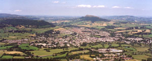
View from the Blorenge, a mountain in South East Wales
Foxhunter car park
In 1952, Sir Harry Llewellyn rode Foxhunter to take Gold in the Helsinki Olympic. The remains of the horse are buried near the car park, with a small memorial dedicated to him.
Sir Harry Llewellyn himself died at the age of 88 in November 1999, at his home in Abergavenny. His ashes were scattered over the Blorenge mountain.
Getting there by car
From Abergavenny, head out towards Llanfoist along the B4246. Keep going through the village and on towards Govilon. At Govilon take a left turn, signposted Blaenavon. This takes you over the Monmouthshire and Brecon canal, around a couple of tight hair pins, and then a steep climb brings you up the side of the Blorenge mountain. There are some good views looking back across the Usk valley, but try to keep your eyes on the road ahead as there are often sheep wandering across the road. Keep going past the Cordell Country Inn (named after the local author) until the road begins to level out. On the left you will see Keeper’s Pond, then take the second left (the first left takes you to the pond). About a mile along this road you will come to Foxhunter car park on the left, opposite some big radio masts.
The path should be fairly obvious from the car park as it is well worn, and there are usually some other people around who look as though they know where they are going. Look out for the Foxhunter memorial as you leave the car park (see side panel for more information). Simply follow the path (heading away from the radio masts) until you get to the front of the Blorenge. Note – the ground here is rough and you may have to scramble over loose stones and rocks in places.
It can be slippery up here, so be careful. But this simply has to be the best view in the area. The whole of Abergavenny is laid out beneath you, with the Sugarloaf and Skirrid mountains providing the back drop.
Rhyme for ‘orange’!
Blorenge rhymes with orange! The only other word in the English language that rhymes with orange is ‘sporange’, which is in the Oxford English Dictionary, and is a botanical term.
Sam Murray, from Philadelphia won $1 million in 2009 on the TV show “Who wants to be a millionaire” after the last remaining competitor Jehan Shamsid-Deen failed to answer this question:
A rare example of a word that rhymes with ‘orange’, the Blorenge is a what?
A: River in Ireland, B: Forest in Scotland, C: Mountain in Wales, D: Desert in Australia
Things to look out for
River Usk: you should be able to trace the path of the river as it meanders through the valley.
Town Hall: Try and spot its distinctive green roof
The Castle: You may just be able to make out the castle ruins, not too far from the town hall.
The Sugar Loaf: from this position, you can clearly see how the Sugar Loaf mountain forms the Deri, the Rholben, and Llanwenarth Breast (from right to left)
Planning a walk? Check the weather before you go on the Abergavenny web cam.